Photo by D. McClure, July 2000, ref. 0072/10a.
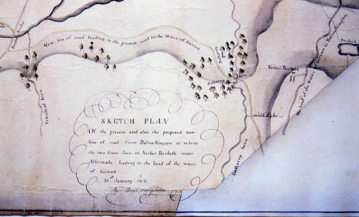
Photo by D. McClure, July 2000, ref. 0072/8a.
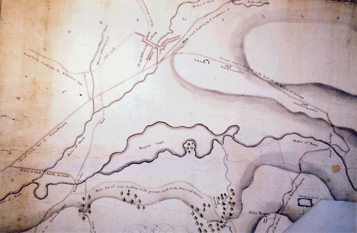
Photo by D. McClure, July 2000, ref. 0072/7a.
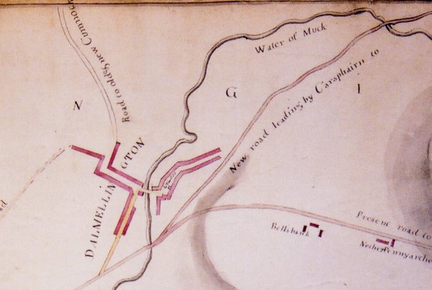
Photo by D. McClure, July 2000, ref. 0072/9a.
See also The Dalmellington Volunteers
Like his father John before him, Quintin McAdam of Craigengillan (also known as Berbeth) was an active roads trustee; between 1st January 1791 and 2nd November 1804, he attended 11 general meetings of the Ayrshire Roads Trustees in Ayr.(1)(2) With his house standing on the Carrick side of the Water of Doon in the parish of Straiton and Dalmellington on the Kyle side, he served on committees for roads in both these districts of Ayrshire. On 6th August 1793 he was appointed to the committee "For the management of the roads in the Carrick parishes of Maybole, Kirkmichael, Dailly, Kirkoswald, Straiton and Barr", with the Earl of Cassillis, Sir Adam Fergusson of Kilkerran and Sir John Whitefoord of Whitefoord [Blairquhan] among 17 fellow members. On 30th April 1795 a new committee of 19 was appointed for the road from Ayr to Dalmellington; Quintin McAdam of Craigengillan was its convener. Three years later he was one of 9 new members added to the committee on the road from Dalmellington to New Cumnock. As the members of the committee on the road from Ayr to Dalmellington were, by 16th January 1800, "mostly dead", a new committee was formed with Quintin McAdam among the members, though the new convener was the provost of Ayr. In 1804 he was a member of both the Kyle and Carrick committees responsible for drawing up the bill which resulted in the 1805 Ayr Roads Act.
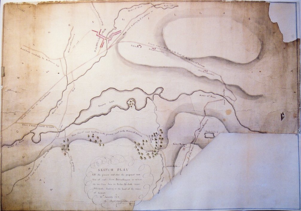
The principal roads in the area are shown in a map displayed in the Cathcartston Interpretation Centre in Dalmellington, bearing the following description: "Sketch Plan of the present and also the proposed new line of road from Dalmellington to where the two lines Join in Nether Berbeth moor afterwards leading to the head of the water of Girvan. 31st January 1803. [Signed] By Bryce Macquiston."
The following four photographs show the map:
|
A view of the whole map. It will be seen that it it has been damaged and
is incomplete.
Photo by D. McClure, July 2000, ref. 0072/10a. |
|
An enlarged view of the title, showing also Nether Berbeth.
Photo by D. McClure, July 2000, ref. 0072/8a. |
|
An enlarged view, showing Dalmellington, the Water of Doon and Bogton
Loch.
Photo by D. McClure, July 2000, ref. 0072/7a. |
|
An enlarged view showing Dalmellington.
Photo by D. McClure, July 2000, ref. 0072/9a. |
The following is a list of the roads shown and named, proceeding clockwise around the map:
"Road from Ayr to Dalmellington."
"Road from Stairbridge by Kirkmean Hill."
"old road" - continuation of (2) into Dalmellington.
"Road to old & new Cumnock."
"New road leading by Carsphairn to Kirkcudbright."
"Present road to Berbeth & the head of the Water of Girvan."
"[missing] the head of the Water of Girvan to Dalmellington" - continuation of (6).
"New line of road leading to the present road to the Water of Girvan".
"Road from Straiton to Dalmellington."
"Where a road should be made" - leaving (1) to join (10) near "Bogton bridge".
In terms of this map, the Dalmellington bypass attributed to Quintin McAdam is the continuation of (5), the "New road leading by Carsphairn to Kirkcudbright" to meet (1), the "Road from Ayr to Dalmellington", without entering the village. This is the line of the A713 today. It is fortunate that we have been left a contemporary description of both the old entry to Dalmellington from the southeast, and of the new road, in Richard Hodgkinson’s account of his travels in Scotland in 1800.(3)
Hodgkinson was astonished that, considering that Dalmellington comprised so very few houses, they should be "so inconveniently jumbled together ... upon the side of a Hill of steep descent" by the burn known unpoetically as the Water of Muck. Entering "the town" from the southeast at the "upper end", the traveller came upon a sharp turn "into a street which admits of only one carriage at a time", although further down there was a "spacious opening before the principal Inn".(4) It was not paved and consisted of "a rough gravel which is very much torn up by the rapid descent of the Rains down so steep a pitch". Hodgkinson turned from his criticism of the village street to compliment "the Gentlemen of Scotland" for the attention they paid to laying out new roads, and to note in particular Quintin McAdam, a young man "who has by his influence & the weight of his purse gained almost dictatorial authority abt [sic] the Roads in this neighbourhood." "By one bold effort" he had made a new road which did not come within 200 yards of the town, "by which you escape not only the danger & difficulty of going through the Town but the Road is kept upon a better level". Hodgkinson goes on to describe how McAdam had to carry the new road through "extensive Moss deep & rotten", and how over the course of three or four years and at a personal expense of £400, he had prevailed.(5)
Of course Quintin McAdam had an interest in the whole course of the road. On 5th June 1801 he attended a meeting in Ayr to discuss the line of the road between Polnessan and Ayr, in connection with a survey by Charles Abercrombie.(6) The minutes of a meeting he attended on 1st August the same year record the involvement of the author of the above sketch map, Bryce Macquiston, in the road.
"But as the whole Proprietors thro whose Property the Road at present goes, or is intended to be carried after the alteration shall be made therein from Dalmellingtoun to the March of the Parish of Ayr, Are satisfied with the Alteration from Ponnessan Burn [Polnessan] to the March of the Parish of Ayr as now lined of by Brice Macquiston upon Mr Abercromby’s Pan as well as a New Plan made out by himself having the different Lines of Road delineated thereon, They therefore adopt that Line in preference to that mentioned in the Minutes of [5th June]."
It is clear that Bryce Macquiston was responsible for another map or plan showing the line of the road running northwest from Dalmellington to Ayr.
There would have been minute books for the parish of Dalmellington and for the individual roads with which Quintin McAdam was associated, but none of these are presently among the public records or listed among estate papers. However both Hodgkinson’s journal and Macquiston’s map survive to record the contribution of Quintin McAdam to the infrastructure of Dalmellington in the late eighteenth and early nineteenth centuries.
Quintin McAdam shot himself on 22nd March 1805.
© David McClure
This article was first published on the Ayrshire History website on 15th November 2000.
David McClure, Tolls and Tacksmen: Eighteenth Century Roads in the County of John Loudon McAdam (AANHS, 1994).
CO3/4/1, minutes of general meetings of Ayr Roads Trustees, 1767-1805. Ayrshire Archives.
L15/1-4, Hodgkinson and Jackson Family Papers, Manchester Central Library Archives Department; includes [L15/2/1-12] the Journals of Richard Hodgkinson of Atherton, Lancs., estate agent. Florence and Kenneth Wood (eds.), A Lancashire Gentleman: The Letters and Journals of Richard Hodgkinson 1763-1847, (Alan Sutton, Stroud, 1992). See also "The Dalmellington Volunteers", another article on the Ayrshire History website.
In his account of the parish, the minister Duncan McMyne notes that "it has 5 or 6 public houses, kept by people of good character" [Statistical Account of Scotland, Dalmellington, Rev. Duncan McMyne (1792)]. No inn is recorded in the window tax records for 5/4/1797 to 5/4/1798 , which implies that even the best inn had fewer than 7 taxable windows and was far from being a grand establishment [E326/1/16, Assessed Taxes Schedules, Window Tax, Ayrshire Apr. 1789 - Apr. 1798. National Archives of Scotland]. The inn may have been Gilbert McKinlay's Cross Keys. See The Dalmellington Volunteers, Appendix 1.
The accuracy of his observations is not beyond question. He records the "lake called Dom-loch, seven miles long & a mile broad" [Loch Doon], and its small island with a castle, but errs in noting that "the River Ayr runs through this Loch".
CO3/5/3a, District of Ayr Road Trustee Records 1781-1827. Ayrshire Archives.
See also CO3/5/32, Kilmarnock District Roads Trustees, minute book 1830-1835; Mr Macquiston to be paid £9 for his survey at Flockside.