Dundonald
[Vol. VII, pages 615–625]
(County and Presbytery of Ayr, Synod of Glasgow and Ayr.)
By the Reverend Mr Robert Duncan.
Name and Situation
No word in the English language accurately determines the form of that rising ground which is know in Scotland by the Celtic term, dun. The parish of Dundonald derives its name from an eminence on which stands an antient [sic] and royal castle. In this castle lived and died Robert II, the first King of the Stewart line. From Irvine harbour, which is within its limit, this parish extends eight English miles along the sea cost, terminates on the south, at the place where the Rumbling and Pow–burns meet, and discharge themselves into the sea: A place which, on account of its quick sands, is very dangerous to travellers.
[616]
Soil and Appearance
The parish of Dundonald presents as great a variety in point of soil and external appearance as is to be met with in any part of the kingdom. The Claven hills, and Shoualton moss, which lies immediately under them to the north, divide it almost into two equal parts; upper, and lower. The former being inland, is, in general, pf a fertile clay, though some farms are more inclined to a loamy, and two or three to a light texture. This part of the parish consists of gentle eminences, adorned with clumps and belts of planting. The lower part, between the hills and the sea, is very flat. Some barren sandy hillocks are to be seen in different places by the shore. Cutting the bent, which grows upon them, no doubt, adds to their barrenness, and renders them a better sport to the winds. However, there is a great extent of arable, and especially of good pasture, ground near the sea, and particularly about the Troone. Half a mile inward, and along the skirts of the hills, is a mixed soil of excellent quality; very proper for culture, and which, after regular tillage, runs immediately into rich grass.
The Claven hills consist of various heights, and extend about three miles from south–east to north–west, and a mile and a half from north–east to south–west. Many of these heights are arable, all of them afford pasture, and some of them have their shelving sides ornamented with oak, ash, birch, alder, hazle [sic], &c. None of them are so elevated as to require critical measurement, or comparison with many hills in the county of Ayr, yet they have long been distinguished by particular names. The two highest are stiled [sic] the Lamont and Warley hills. Perhaps the latter, which overtops the rest, is a corruption for warlike; the lines of two encampments being still distinct upon it. These are usually designed Roman encampments, though their form appears sufficiently to confute that designation. The largest contains, within a circular embarkment [sic] of loose stones and earth then [617] acres of ground; and there is an inner circle of the same kind, and from the same center [sic], which incloses one of these acres. The other encampment is about two hundred yards distant. No artificial work has ever been raised upon its north–east quarter; the steepness of the declivity being a sufficient defence. But, on the south and west, the circular embankment is strong, and within is a beautiful platform not exceeding an acre in extent. Historians seem to agree that the Norwegians, who afterward were defeated at Largs, landed near to Ayr; and it is not improbable that these heights were immediately occupied, and in this manner fortified, by them. No place could be more proper for their purpose, both on account of the extensive prospect, and of its great security before the invention of fire arms. A person standing within either of these encampments, is entertained with a delightful prospect, to the south, of the lands lying upon Ayr and Doon rivers; and the prospect, upon this quarter, is terminated by the high hills of Carrick and Galloway. Turning to the north–east, Cunningham and part of Kyle exhibit a grand and rich amphitheatre, at least 14 miles in diameter. In a clear day, the eye is lost among hills streaching [sic] far beyond Ben–Lomond. To the west, the spectator has a noble view of the frith of Clyde, of Bute, Cumbraes, Cowal, the Paps of Jura, Arran, Plada, Sanda, the point of Cantyre [sic], and different parts of the kingdom of Ireland appearing between Kintyre and Ailsa. The singular form of this last island, rising like a mighty pyramid from the ocean, is beautifully contrasted by the similar appearance of Loudon [sic] hill, rising on the opposite side from the land. No wonder that the inhabitants of the bleak mountains of Scandinavia were captivated with the prospect, and excited to contend vigorously for the possession of this part of Scotland.
[618]
Population
In 1755, the number of souls was rated at 983. In 1792, the total is 1317. Of these,
|
Males |
658 |
|
Females |
659 |
|
Below 10 years of age |
338 |
|
From 10 to 20 years |
293 |
|
From 20 to 30 |
220 |
|
From 30 to 40 |
165 |
|
From 40 to 50 |
146 |
|
From 50 to 60 |
82 |
|
From 60 to 70 |
43 |
|
From 70 to 80 |
26 |
|
From 80 to 90 |
3 |
|
From 90 to 100 |
1 |
|
Annual average of births during 28 years |
35 |
|
Annual average of marriages |
16 |
|
Annual average of burials |
17 |
Rent
Valued rent £6367 15s 5d Scots. Real rent about £6100 Sterling.
Church, School, and Poor
To the ministers stipend, which formerly was 100 bolls 14 pecks of meal, 32 bolls 11 pecks of bear, Ayrshire measure, and 20 merks Scots; the Lords Commissioners of teinds have, this year, granted an augmentation of £25 3s 2½d Sterling, and £5 Sterling to defray the expence of communion elements. The manse was rebuilt in 1784, upon a very neat plan, and was the first in this part of the country, which had slated offices. The glebe is 4 acres. No grass is allowed for horse or cows. The schoolmasters salary is 100 merks Scots. The average of scholars, 34. The inhabitants are obliged to keep two private schools, in two corners of the parish, which are at too great a distance [619] from the kirk town, for their young children. The schoolmaster has a dwellinghouse and schoolhouse, but no garden.
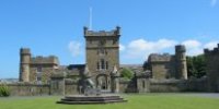
The funds for the poor are, the interest of £144 stock in the bank of Ayr, the monies received at private baptisms and for mortcloths, and the weekly collections: The average of the provision for the poor for nine years past, is £36. Seven persons, receive, at present, a weekly pension from 1s to 1s 6d; and eleven receive occasional supply. None are allowed to beg. Near to the village of Dundonald, is the castle already mentioned, which gives name to the earldom in the family of Cochrane. The rising ground on which the castle stands, with 5 roods of land adjoining, is all the property in this parish which now pertains to that family. No authentic record can be produced at what time this castle was built, or when it was spoiled of its roof, and rendered desolate. A large pile still remains: The walls are very thick, and built of whinstone, which is in abundance near it. The corners are of a freestone, superior in quality to any now found in the parish. The Stuart arms are engrossed in different parts of the building, and the whole has much the form of those castles which were raised in many places of Britain during the 12th and 13th centuries. Among the hills is still discernable [sic] the vestige of another castle, called Kemplaw, and which is said to have been of high antiquity.
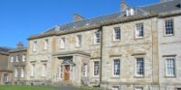
Opposite to the village and castle is a very beautiful bank of wood, upwards, in most places, of 100 feet in height, and extending near a mile to the northwest. In a grand curvature of this bank, and on a gentle eminence, stands the house of Auchans, for a long period the residence of the Wallaces of Dundonald. About 1640, this estate came into the possession of Sir William Cochrane of Lowdon [sic], knight; who was afterwards created Earl of Dundonald. Since the beginning of this century, the estate has been the property of the [620] Earl of Eglintoune, who, with it, acquired the patronage of the parish. At the Auchans, are the remains of a small orchard which was once in high reputation. The pear, known in Scotland by the name of Auchans, derived that name from this place. The tree came originally from France, was planted in this orchard, grew to a great height, and was, not long ago, blown down by a storm. Some large trees, particularly planes and ash, may be seen in different parts of the parish, especially at the Auchans.
Heritors
The heritors of the parish are in number 16, and, excepting two of them who have only 39 acres, reside either within the bounds of the parish, or in its vicinity. The houses of Fullerton, Fairlie, Hillhouse, and Newfield are modern buildings, very commodious and elegant in their respective forms. To Mr Fairlie of Fairlie, the country is indebted for a considerable share of its improvement in agriculture. Of this not only his own estate in this parish, but the numerous estates belonging to the Earl of Eglintoune, in the counties of Ayr, Lanerk [sic], and Renfrew, all under his management, are a sufficient demonstration. Persevering with uncommon firmness in combating the prejudices of old tenants, dividing the lands and making restrictions suitable to the soil and situation, he has rendered the farmers, in general, more wealthy and respectable, and the lands much more valuable. To Mr McKerrel of Hillhouse, the country is under great obligations in another line. He was the first who introduced the silk manufactory into Paisley, and his sons still carry it on to a considerable extent. Colonel Fullerton of Fullerton, and Major Crawford of Newfield, particularly distinguished themselves in the East Indies.
Fuel
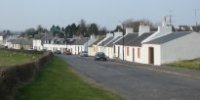
This parish is well situated for fuel. Shoualton [621] moss, which is of an irregular figure, near 4 miles in circumference, is an inexhaustible fund for peat. But there is little demand for peat owing to the abundance of coal. At Fairlie a seeing coal has been wrought for many years for the benefit of the country, and, for some seasons, past, a good blind coal, which is exported at Irvine for the Irish market. On account of this coalwork, a village, named Rumford, has of late years started up close by Fairlie bridge. It contains at present 74 inhabitants. At Shoualton a seeing coal is wrought both for the use of the people in the town and neighbourhood of Irvine, and for exportation. The load of coals has lately been raised, and is now sold at the former of these works at 8d, and at the later 10d. These coallieries [sic] employ many sailors and carters in Irvine, and during the summer and winter months, a number of tenants, who, by these means, give constant work to their horses.
Miscellaneous Observations
A cotton work has lately been erected in the village of Dundonald, which employs 30 persons, old and young. The carding machines are turned by a horse. Excepting 6 weavers, 3 taylors, 4 shoemakers, 2 masons, 4 joiners, and 3 smiths, the rest of the inhabitants, able for work, are employed in agriculture. Land is let from 15 to 30 shillings per acre, according to is quality. Most of the farms are in 3, some in 4, breaks. Oats and bear are the principal articles of culture. There are 3 mills upon this side of Irvine river. One of them for oats; another for oats and lint; and the third, lately built upon the land of Shoualton, at considerable expence and with great improvements, for wheat, oats, and barley. No lime has ever been discovered in this parish. The farmers in the lower part of it have for many years imported lime–stone from Ireland. Considering the greater quantity of calcareous [622] earth in the Irish lime, they are at less expence for this kind of manure than to cart it from the neighbouring parishes of Symington and Riccartoun. They have likewise the advantage of sea–wrack. Notwithstanding the hills and moss already mentioned, the parish produces more than double the quantity of grain necessary for its own consumpt [sic]. The attention of the farmers has, of late years, been turned to the rearing of young cattle, both horses and cows, and to the making of sweet–milk cheese. Both must in a short time be highly beneficial to the country; much money having long been drained out of it, to England for cheese, and to Ireland for horses. In summer 1791, there were in the parish 235 draught horses, 120 young ditto, 14 bulls, 597 milch cows, 782 young ditto, bulls and stots; 433 black cattle feeding for market; 1090 sheep, viz. 603 of the small kind and black faced, 338 of a mixed breed between the English and Scotch, white faced; a Turkish ram brought by Colonel Fullerton from Constantinople in 1790, and 48 lambs the offspring of this foreigner, and ewes of the mixed breed.
There are 4 licenced [sic] public houses in the parish; but the inhabitants are, in general, very sober and industrious. Their mode of living is much improved within these 20 years. Their way of living and their industry have a mutual influence. No customs or amusements are peculiar to them. Great weddings are fast going into disuse. Country burials are not well regulated. The company are invited at 11 o'clock forenoon, but they are, probably, not all arrived at 2. Till of late a pipe and tobacco were provided for every one of the company, but this custom is entirely laid aside. An antient practise [sic] continues in this parish and neighbourhood of kindling a large fire, or tawnle as it is usually termed, of wood, upon some eminence, and making merry around it, [623] upon the eve of the Wednesday of Marymass fair in Irvine. As most fair days in this country were formerly popish holy days, and their eves were usually spent in religious ceremonies and in diversions; it has been supposed, that tawnles were first lighted up by our catholic fathers, though some derive their origin from the druidical times.
The Troone, which might be made an excellent harbour, is the west point of Dundonald parish. In its natural condition, it affords safe anchoring ground from every quarter but the north–west. It is an arm of rock running near a mile into the sea, and bending from south to north, broad and covered with rich pasture towards the land, and narrowing into a barren point, part of which is for a little distance concealed even at low water. Within the point at half a cables length from the rock, the mariner may trust to have three fathoms water at half–flood. The merchants of Glasgow, sensible of the advantages of this natural harbour, near a century ago made offer to the proprietor of feuing the lands adjoining to it. But their offer was rejected, for a reason, as it is reported, which however ridiculous it may now appear, would be accounted very cogent in those days; lest a rise should be occasioned in the price of butter and eggs. The place, where Port–Glasgow now stands, was deemed by the merchants the next station most eligible for their trade. The Lady–isle, which lies in the mouth of Ayr Bay, is a pendicle to this parish; and, as it affords security to vessels upon this flat and dangerous coast, the Magistrates of Glasgow have erected two pillars to direct them. Upon the Troone stands [624] an elegant octagonal temple, built by the late Fullarton, who was a gentleman of classic taste. This temple commands an extensive prospect, and is, Baccho laetitiae dotori, amicis et otio sacrum. The Troone is an excellent situation for sea bathing, and is much resorted to by the inhabitants of Kilmarnock, and of other inland parts. People from Elgin carry on fishing of salmon at the Troone, and the Black–rock which is near a mile to the southward. In dry summers they are most successful, as floods give the salmon an opportunity of ascending the neighbouring rivers. Salmon, when most abundant, are sold at [625] 4d per pound. There are some lobsters and crabs among the rocks. Some tons of kelp are made, every third or fourth year, from the sea weed which grows upon the rocks. Colonel Fullerton has lately built a house at the Troone, for drying the sea–weed thrown in by the surf, and for making kelp from it. But, it is very uncertain, whether a manufacture of this nature will yield a profit sufficient to recompense the loss of manure. The Colonel has two extensive rabbit warrens near the shore; both of them very thriving. While the Isle of Man remained a distinct sovereignty, the Troone was found to be a very convenient station for vessels employed in contraband trade. The British government gave the first check to smuggling upon this coast, by purchasing the regal power of that petty state. Happily the commutation act has nearly annihilated the hostile traffic. It must be acknowledged, that lessening some duties to a certain degree would not injure the revenue; and yet more effectually cut up this business, that a fleet of cutters, or an army of custom and excise officers. Uncontrovertible evidence must convince every attentive man, living upon the coast of Ayrshire, of the great wisdom of the apostle, in joining those two precepts in one sentence, Fear God, Honour the King. Smuggling, in its very nature, tends to weaken in the dealer that sense which he has of lawful authority, to disturb his peace, to injure his health, to corrupt his manners. Must it not be regretted, that men of amiable dispositions should be seduced by the temptations of this trade. Were profit and loss upon it clearly calculated, the balance would be much against the profit side, putting health and peace and character out of the question.