 |
 |
 |
 |
Research Postings |
 |
Copyright notice: Links to this site are welcomed. However none of the material on the site may be duplicated in any form. The copyright of the articles is the property of the authors. Copyright of the web pages is the property of David McClure. |
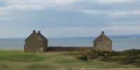
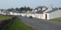
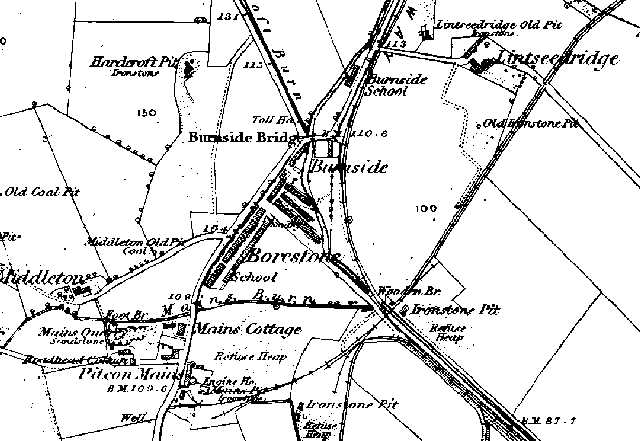
Burnside and Borestone, Dalry
Below: A section of the 1856 OS map showing Burnside. |
Burnside Row, Dalry I am researching my GGGrandparents, Miles & Margaret (McShane) McCann. Miles died in Dalry in 1869 at age 61. They were living on Burnside Row at the time of his death. Both ancestors were born in N. Ireland, circa 1808. Miles was an iron miner. Their children include Alice, b. N. Ireland in 1836, Mary, b. Lanarkshire, 1844, John, b. 1849 Kilbirnie, Patrick, b. 1852 Kilbirnie and Margaret, b. 1856 Kilbirnie. Any help greatly appreciated. Trudy. From David McClure: Please note that this is not a family history site. Genealogical enquiries will not be posted unless there is an aspect of the enquiry which I feel is of wider interest and utility. This is a case of point. Burnside does not appear on modern OS maps, though Burnside Bridge appears on 1:25,000 maps (not 1:50,000). According to the 1st OS (1856) Burnside was at NS296512, immediately on the SW side of the junction of the B780 [road numbers are modern] with the B784, between the junction and a lane which is still there. On the other (W) side of this lane lay the similar Borestone. Both consisted of miners' rows. Neither appear in Ayrshire Miners' Rows 1913, possibly because they had been abandoned before that date. The B780 crosses Burnside Bridge over the Pitcon Burn on the N side of the junction. There was a Burnside School on the E side of the B780, between the junction and Lintseeridge farm lane. There was also a school in Borestone. Borestone and Burnside were situated between the junction and Pitcon Mains. A toll house stood on the B784 adjacent to the junction. There were both ironstone and coal mines in the neighbourhood. Ironstone was not being mined in the parish at the time of the New Statistical Account (June 1836), though the author (Rev. Thomas Johnstone) mentions ironstone on the estate of Swinridgemuir, and its recent discovery on the estate of Blair, the largest in the parish. It is clear from the account that the mining settlements of Burnside and Boreland did not exist at the time of writing. They were created between then and 1856. |
 |