 |
 |
 |
 |
Research Postings |
 |
Copyright notice: Links to this site are welcomed. However none of the material on the site may be duplicated in any form. The copyright of the articles is the property of the authors. Copyright of the web pages is the property of David McClure. |
Dalmellington Motte
From
Jim Jeffrey, 26 September 2006: Have an Ayrshire History
query that occurred to me last night as I watched a documentary
on "Pagan" England. In that program they showed a hill
(Simsbury area?) constructed primarily they now think as a signaling
site. It reminded |
|
 |
|
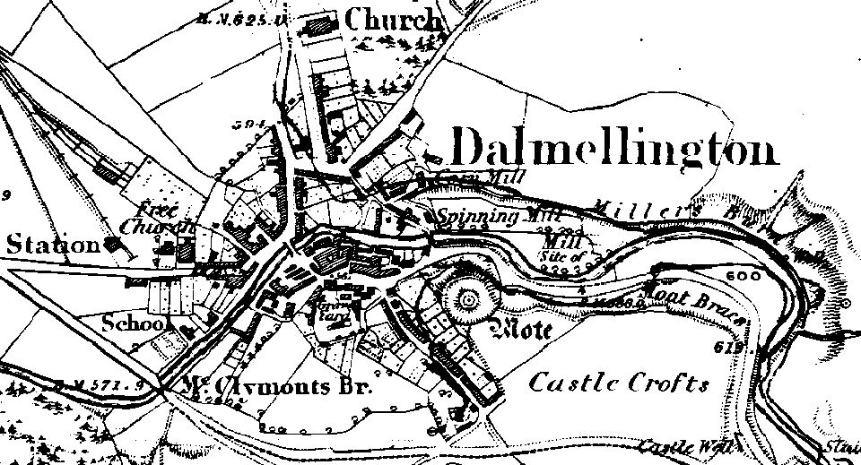
From David McClure: See the first OS map above (1857). The best source for information is the RCAHMS database, from which I have obtained the following information.
Archaeology Notes © RCAHMS
NS40NE 3 4819 0580. (NS 4819 0580) Motte (NR)
Dalmellington Mote is nearly circular, 60ft in diameter on the level top, and slopes steeply to a trench which cuts it off from the Castle Crofts plateau on the E and S, and from the slope to the village westward. To the N, a narrow terrace completes the circuit. The trench is 6 to 9ft wide at the bottom, and has an outer, flat-topped low rampart on the W side. The mound rises about 30ft above the terrace and some 60 to 70ft above the village. The mound was superficially restored about 40 years ago. D Christison 1893
This well-preserved motte is generally as described by Christison. The height of the counterscarp of the ditch is 1.5m, and the terrace is, on average, 3.0m wide. Visited by OS (JLD) 15 July 1954
The motte is still as described above. Visited by OS (WDJ) 9 November 1959
No change to the previous information. Visited by OS (MJF) 17 September 1980
NS 482 058 A watching brief was maintained in November 2002 during
the erection of four lighting columns, the excavation of a trench
for an underground cable, and the refurbishment of stairs. The concrete
steps were each removed and the bedding levelled before being replaced.
The trench was excavated along an existing path to cause as little
disturbance as possible. No features of archaeological significance
were identified. Report lodged with WoSAS SMR and the NMRS. Sponsor:
East Ayrshire Council. S Coulter 2003 References Christison, D (1893 b) |