|
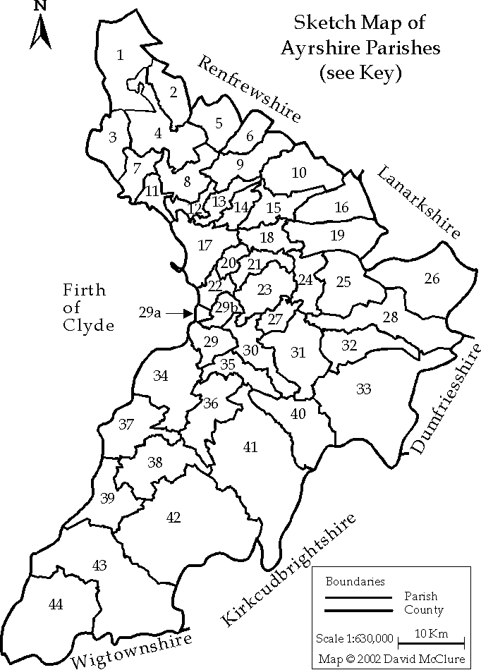
Ayrshire
Parish Map
Point to a number on the map to see the parish name.
A complete list of Ayrshire parishes with their key numbers will
be found in the table below.
The parishes have been numbered as in the Third Statistical
Account of Scotland: Ayrshire, Strawhorn, John and Boyd, William,
eds., 1951. Newton-upon-Ayr and St. Quivox had before then become
part of Ayr parish. They are shown separately here, numbered 29a
and 29b respectively.
This map was first published in Ayrshire in the Age of Improvement,
McClure, David, ed., Ayr, 2002.
Please note that this map is copyright and may not be reproduced
without permission. |
|
Table of Ayrshire Parishes
Click on a parish name to go to its Old Statistical Account(OSA) |
Parish |
Key |
Length
(miles) |
Breadth (miles) |
Acres
Scots |
Pop.
1755 |
Pop.
1790-8 |
Pop.
1801 |
|
Cunninghame (16) |
|
|
|
|
|
|
|
|
Ardrossan |
7 |
9 |
2 |
9,000 |
1297 |
1518 |
1846 |
|
Beith |
5 |
5 |
4 |
10,000 |
2064 |
2872 |
3103 |
includes 'Island and Parish of the Cimbraes' |
Island and Parish of the Cimbraes |
|
|
|
|
|
|
|
|
Dalry |
4 |
8 |
8.5 |
36,600 |
1498 |
2000 |
2321 |
|
Dreghorn |
13 |
9 |
3 |
13,000 |
887 |
830 |
762 |
|
Dunlop |
6 |
7 |
2.5 |
8,000 |
796 |
779 |
808 |
|
Fenwick |
10 |
9 |
6 |
27,000 |
1113 |
1281 |
1280 |
|
Irvine |
12 |
4 |
2.5 |
5,000 |
4025 |
4500 |
4584 |
|
Kilbirnie |
2 |
|
|
11,000 |
651 |
700 |
959 |
|
Kilmarnock |
15 |
9 |
4 |
13,000 |
4403 |
6776 |
8079 |
|
Kilmaurs |
14 |
6 |
3 |
9,400 |
1094 |
1147 |
1288 |
|
Kilwinning |
8 |
9 |
8 |
36,000 |
2541 |
2360 |
2700 |
|
Largs |
1 |
9 |
2 |
9,000 |
1164 |
1025 |
1361 |
|
Loudoun |
16 |
9 |
7 |
18,000 |
1494 |
2308 |
2503 |
|
Stevenston |
11 |
2.5 |
2.5 |
3,300 |
1412 |
2425 |
2146 |
|
Stewarton |
9 |
10 |
4 |
19,000 |
2819 |
3000 |
2657 |
|
West Kilbride |
3 |
6 |
3 |
9,000 |
885 |
698 |
795 |
|
Carrick (9) |
|
|
|
|
|
|
|
|
Ballantrae |
44 |
10 |
|
49,000 |
1049 |
770 |
837 |
|
Barr |
42 |
|
|
50,000 |
858 |
750 |
742 |
|
Colmonell |
43 |
16 |
7 |
48,000 |
1814 |
1100 |
1306 |
|
Dailly |
38 |
6 |
6 |
18,000 |
839 |
1607 |
1621 |
|
Girvan |
39 |
9 |
6 |
27,000 |
1193 |
1725 |
2260 |
|
Kirkmichael |
36 |
9 |
4 |
18,000 |
710 |
956 |
1119 |
|
Kirkoswald |
37 |
6 |
|
10,000 |
1168 |
1335 |
1679 |
|
Maybole |
34 |
12 |
7 |
41,000 |
2058 |
3750 |
3162 |
|
Straiton |
41 |
15 |
5 |
37,000 |
1123 |
934 |
1026 |
|
Kyle (21) |
|
|
|
|
|
|
|
|
Auchinleck |
28 |
18 |
2 |
18,000 |
887 |
775 |
1214 |
|
Ayr |
29 |
4 |
2 |
4,000 |
2964 |
4647 |
5492 |
|
Coylton |
30 |
7 |
2 |
7,000 |
527 |
667 |
848 |
|
Craigie |
21 |
7 |
1.5 |
5,000 |
551 |
700 |
786 |
|
Dalmellington |
40 |
8 |
3 |
12,000 |
739 |
681 |
758 |
|
Dalrymple |
35 |
6 |
2 |
6,000 |
439 |
380 |
514 |
|
Dundonald |
17 |
9 |
7 |
31,000 |
983 |
1317 |
1240 |
|
Galston |
19 |
13 |
5 |
31,000 |
1013 |
1577 |
2139 |
|
Mauchline |
24 |
7 |
4 |
14,000 |
1169 |
1800 |
1746 |
|
Monkton & Prestwick |
22 |
4 |
2.5 |
5,000 |
582 |
717 |
986 |
|
Muirkirk |
26 |
10 |
6 |
30,000 |
745 |
1100 |
2560 |
|
New Cumnock |
33 |
12 |
8 |
49,000 |
1497 |
1200 |
1112 |
|
Newton-upon-Ayr |
29a |
1.5 |
1 |
750 |
581 |
1689 |
1724 |
|
Ochiltree |
31 |
6 |
5 |
14,000 |
1210 |
1150 |
1308 |
|
Old Cumnock |
32 |
10 |
2.5 |
12,500 |
1336 |
1632 |
1798 |
|
Riccarton |
18 |
6 |
2 |
6,000 |
745 |
1300 |
1364 |
|
St. Quivox |
29b |
|
|
3,300 |
499 |
1450 |
2070 |
|
Sorn |
25 |
|
|
19,000 |
1494 |
2779 |
2606 |
|
Stair |
27 |
6 |
2 |
6,000 |
369 |
518 |
663 |
|
Symington |
20 |
4 |
1.5 |
3,000 |
359 |
610 |
668 |
|
Tarbolton |
23 |
9 |
5 |
22,000 |
1365 |
1200 |
1766 |
|
|
The dimensions and population data in
the table are taken from Appendix II in the following book: William Aiton,
General View of the Agriculture of the County of Ayr, Glasgow
1811. His figures for the population in 1755 are those of the Rev. Webster,
and for the population 1790-8 are those to be found in the Statistical
Account of Scotland, 1791-9, commonly referred to as the Old
Statistical Account, or OSA. |